
The city of Kobe is currently moving forward with major street improvements which will culminate in the total pedestrianization of downtown’s Sannomiya area (a major commuter rail hub with no less than six stations). This will greatly enhance the overall appeal of central Kobe, and could be a real game changer for international tourism.
The following is a rough translation of this press release, which describes the upcoming reconstruction of a side-street near the Sannomiya area. The scale is quite small compared to the coming improvements, but it appears to be representative of Kobe’s human-centric approach to urbanism.
Please view the PDF for best results.
Rebirth of Route 54 (Fukiai-Minami) as a Pedestrian Priority Street
(Road Redesign)
Goals
- As a part of urban place-making wherein Kobe becomes a city where residents want to keep living forever, Kobe is seeking to become a “city you will choose” by capitalizing on its various natural features, such as the sea, the harbor, and mount Rokko.
- In September of 2015, [documents named] “the future shape of Kobe’s urban center (future vision)” and “the area around Sannomiya (basic concept of retrofit)” were finalized, and “the form Kobe should aim for from here on out” was explicated for the central area.
- In this context, the construction department aims to implement “road redesign” as the course of action for road maintenance.
- On Route 54, we are retrofitting a “traffic priority street” whose heart is vehicular traffic into an “open space priority street” where pedestrians can have a great time walking down a street with widened sidewalks.
What We Mean by Road Redesign
In order to respond to the needs of city residents and the issues of the region, we have throughly analyzed the road usage environment and land use situation of the surroundings, and aim to create from a road a public space where one can feel “abundance of life” by designing “qualitative traffic optimization” and “open space improvement”.
Outline of Route 54
- Route 54 is a major downtown area road located east of International House Kobe.
- Along with encouraging people to intermingle by increasing the appeal of the surrounding neighborhood, this road retrofit will create a bustling new space, as a street which lures people from the downtown area to the waterfront.
- Further, in this area, the Sannomiya-South Place-Making Conference is executing an initiative to increase the appeal of the area.
- In order to support and coordinate with this regional initiative, starting in 2012 the construction department carried out a study of the retrofitting of this road (which is one of the main flow lines for movement through this part of the city) while consulting with the place-making conference.
- Based on the results of this study, we are planning to proceed with sequential maintenance, starting with “Downtown/Sannomiya Retrofit” and “Road Redesign”.
Construction Details
Name:
Fukiai-minami Route 54 improvement construction.
Location:
Chuo Ward, Kobe, from Isogami-dori 7-chome to Hachiman-dori 4-chome.
Approximately 130 meters out of a total length of 750 meters.
Schedule:
May 9th to October 10th, 2016.
(may be longer depending on construction conditions on site)
Details:
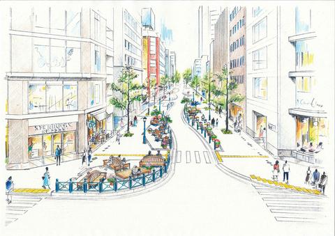
- The total street width of 18 meters -whose current configuration is 2 southbound lanes with parking lanes- will be corrected to 1 southbound lane, and the sidewalk will be widened. (see the attached cross-section)
- In the new space, we plan to increase pedestrian walkability and the pleasantness of the road space by installing benches, etc.
- We plan to control vehicular speeds by making the whole length of the road meander. [c.f. “Mall Street” on the south side of Shinkaichi station]
Contractor:
Kubota Construction Incorporated.
Actual Usage Going Forward
Concurrent with this maintenance construction, on the basis of cooperation between the Sannomiya-South Place-Making Conference and the region, a study of ways in which the street is actually used will be carried out.
Ideas:
- Solicitation of suggestions for a nickname for the street.
- Management and usage of benches, etc.
- Provision and arrangement of flower beds.
- Initiatives to increase liveliness. etc.
Current Condition:

Cross-Section (Before Retrofit):

Artist’s Impression of Retrofit:
Cross-Section (After Retrofit):

Contextual Map and Scope of 2016 Construction:


Construction is now in progress. Photos here: http://koberun.blog56.fc2.com/blog-entry-1072.html
LikeLiked by 1 person
Update on construction progress: http://koberun.blog56.fc2.com/blog-entry-1091.html
LikeLike
More photos of reconstruction: http://koberun.blog56.fc2.com/blog-entry-1119.html
LikeLike
More updates: http://koberun.blog56.fc2.com/blog-entry-1143.html
LikeLike
The final form takes shape: http://koberun.blog56.fc2.com/blog-entry-1161.html
LikeLike
Almost finished: http://koberun.blog56.fc2.com/blog-entry-1216.html
LikeLike