
[ the original version is available here ]
The transportation structure of Japanese cities can be decomposed into pedestrian and vehicular networks. In some places they run side-by-side, in other places they overlap, but for the most part, they are completely separate.
Organizing the hierarchy in order of pedestrian volume, from greatest to least:
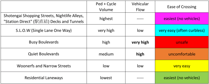
Note that vehicular flow is high only in the middle ranks of the hierarchy (Boulevards), which are marginal in the Kansai (but important in Tokyo). These middle ranks of the pedestrian hierarchy are marginal in two ways:
- Approximately 1/3 of the total length of Japanese streets falls into the Residential Laneway category (physically unreachable by car).
- In the Kansai, the vast majority of shops and businesses are located at the other end of the pedestrian hierarchy; shopping arcades, “nightlife alleys”, station direct linked buildings, and underground shopping malls .
Hierarchy of Japanese Streets: Six Levels
Fully Pedestrianized, Highly Commercialized:
– 6A. Shotengai (shopping streets and arcades, usually connected/adjacent to train stations).
– 6B. Nightlife Alleys – narrow alleys lined with bars, izakaya, etc (usually adjacent to train stations, e.g. Omoide Yokocho). Sometimes under or between elevated tracks.
– 6C. Deck Levels connected to train stations (駅直結).
– 6D. Tunnels & underground shopping malls connected to train stations.
5. SLOW (Single Lane One Way) – streets that use trees or stone bollards to strictly minimize the width of the vehicular path. These streets generally feature very wide sidewalks (#widewalks). May include limited pick-up areas for temporary parking. Usually curbless.
Boulevards – streets with multiple lanes for traffic and/or parking. Invariably includes physically separated sidewalks, usually with trees and/or stone bollards (any exception is noteworthy and will be noted):
– 4. “Busy” Boulevards – unsafe or impossible to cross mid-block. Usually wide multi-lane roads, with traffic and drive-able parking lanes exceeding 10 meters (33 feet) width.
– 3. “Quiet” Boulevards – narrow, multi-lane roads. Safe to cross mid-block. Total road width (traffic lanes + drive-able parking lanes + physically drive-able bike lanes) less than 10 meters (33 feet).
2. Woonerfs & Narrow Streets – slow and very narrow streets where people and cars mix or are separated by a painted line.
1. Residential Laneway – very narrow, few shops if any … physically impassable to cars due to narrow width or the presence of steps.
0. Expressway – elevated or fully subterranean roads that have essentially zero impact on the pedestrian experience, but deliver cars at high speeds.
The aerial views below shows this hierarchy in central Nara and -for comparison- central Minneapolis.
Like Kyoto, Nara was modeled on Chinese capitals, and thus has a relatively more grid-like layout than most Japanese cities. Highlighted as follows:
– Magenta: Arcades and open air, car-free shopping streets.
Magenta Outline: Stations (left end: elevated JR Nara, top: subway Kintetsu Nara).
– Cyan: SLOW street (Sanjo Dori).
– Red: “Busy” Boulevards.
– Orange: “Quiet” Boulevards.
– Yellow: Woonerfs & Narrow Streets.
– Green: Residential (and temple) laneways. Only a fraction (2/3?) are highlighted.

Above: Nara. Total area of highlighted trapezoid: 0.87 square kilometers.
Below: Minneapolis. Total area of highlighted diamond: 0.81 square kilometers.
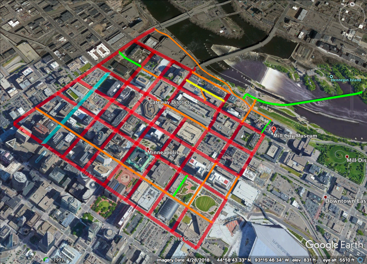
Highlighted as follows:
– Cyan: quasi-SLOW street (Nicollet Mall).
– Red: “Busy” Boulevards (the dominant typology in American urbanism).
– Orange: “Quiet” Boulevards.
Note: Except for having curbs, the Boulevards of downtown Minneapolis lack any form of physical protection (the standard is trees and/or stone bollards).
– Yellow: Alleyway with narrow sidewalks.
– Green: Paseos and the historic Stone Arch Bridge.
The Minneapolis skyway system is not highlighted in magenta, for reasons discussed in this post comparing Minneapolis and Toronto.

11 thoughts on “Hierarchy of Japanese Streets (Version 2)”